New images captured on Chatham Rock Phosphate voyage
/Never before seen images have been taken of the Chatham Rise seafloor, during the just-completed scientific survey voyage by Chatham Rock Phosphate.
A range of scientific data were gathered by scientists on board Odyssey Marine’s 100 m Dorado Discovery vessel during a 11 day voyage to the Chatham Rise to undertake geological and environmental survey work. The vessel returned to Wellington at the weekend.
The data and images gathered involves the most significant research work undertaken of the Chatham Rise since the German vessel Sonne’s major cruise in 1981 as part of efforts by a New Zealand-German joint venture to evaluate the commercial viability of the area’s rock phosphate deposits.
Chatham Rock Phosphate holds an exploration licence over 4276 sq km, 450 km east of Wellington, at shallow depths on the Chatham Rise and in New Zealand territory. The exploration permit is for two years with further priority rights to extend the permit or apply for a mining licence.
Odyssey’s vessel “Dorado Discovery” is specially set up for marine mineral exploration and has been undertaking such work in the SW Pacific for the last 15 months. The Chatham Rock Phosphate work is focusing on underwater surveys with sophisticated multi-beam sounders to map the seabed topography and a special instrument package that contains a magnetometer, sediment sounder and side-scan sonar.
The deep-tow package is being towed at a water depth of 350m 1 kilometre behind the vessel and will provide images of the seafloor for geological and environmental studies, as well as mapping the nature of the sediment in the top few metres of the seabed.
The $US1.2 million voyage involves Odyssey Marine potentially converting cruise costs to equity in Chatham Rock Phosphate.
Some images, emailed back to New Zealand are attached and can be viewed at www.rockphosphate.co.nz.
Dr Robin Falconer, principal scientist of CRP, who was on the Sonne cruise, is very excited by the latest information. “It provides a quantum step in resolution of seabed features compared with the existing 30 year old data. We have only some small samples of data sent by email. The original data will be even better,” said Dr Falconer.
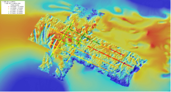
“Figure 1 is an image of the bathymetry; i.e. seafloor topography. The blue areas are deeper than the red. You can see the new detail we now have, as the surrounding “fuzzy” colour is the old data. The new data shown covers a strip about 15km long. We can now see features smaller than 1m in height and a few metres across and dramatic features like the big wedge shapes on the left (western) side. They are almost certainly iceberg plough marks made as icebergs drifted up from the south and ploughed into the seafloor. The big scours are up to 300m wide and 10m deep. Some of the big scours clearly overlap as a new iceberg ploughs over an earlier scour. Elsewhere there are many smaller scours, which may be less distinct because they are older.
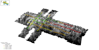
“Figure 2 shows a black and wide perspective view of the same bathymetry. The coloured lines superimposed are the magnetic profiles that were obtained with the deep tow instrument package. The colour codes reflect different magnetic anomaly levels. The data need processing for full interpretation but the anomalies may be related to variations in the amount of glauconite sand on the seafloor. Glauconite (which we are investigating as a second fertiliser product) is quite magnetic as it contains iron in addition to the valuable potassium. In fact magnetic separation is what we would probably use when we were separating it onboard the mining vessel.
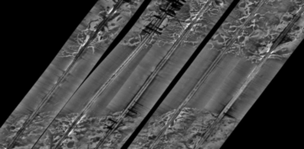
“Figure 3 is a sidescan image from the deep tow instrument package when it was being towed just 50m above the bottom 1 kilometre behind the ship. Sidescan is a sideways-looking sonar that highlights seabed texture and terrain. The figure is a mosaic of several tracks and the uniform area is several kilometres extent. It indicates smooth seafloor sharply separated from rougher or coarser seabed. The coarseness may be patches of phosphate nodules at the seafloor and there will be some seafloor terrain too. Sidescan data may also be valuable for identifying variations in the amount of biota on the seafloor when calibrated with photography on future surveys. “
Netherlands dredging company Boskalis will use the data to refine its already completed preliminary design of the phosphate recovery system. It will also form important baseline data of the environment.
The survey is focusing on the 200 sq km of sea floor already identified as the most prospective area within CRP’s prospecting licence.
Other 2011 activity
The pre-Christmas voyage caps a busy year for CRP, which has also involved:
- Interim capital raising efforts to maintain the project’s momentum, including a share purchase plan, following a decision to delay an Initial Public Offering because of poor international market conditions
- A visit to New Zealand by Boskalis environmental expert Gerard Van Raalte to meet a range of government and other stakeholders
- The signing of a service agreement with Boskalis to undertake a number of projects that collectively comprise phase one of the planned work programme. These projects include design engineering, logistics studies and preliminary design work and environmental studies including turbidity assessments.
The first term of the work programme has involved reviewing and analysing technical data, studying environmental impacts, assessing the project economics and designing an exploration programme as well as engineering design. Significant focus has also gone into working with stakeholders.
CRP is currently compiling a progress report to New Zealand Petroleum and Minerals, which highlights achievements of the past two years of the company’s exploration activity. Activity has included:
- A review of relevant scientific literature and reports
- Digitisation of technical data
- Development of a sample database
- Evaluation of radiometric geophysical techniques
- Deployment of current meters and turbidity sensors
- Sediment sampling
- Environmental baseline data collection including oceanography and habitat.
The year ahead
Detailed planning is underway for the coming year’s technical work programme. CRP’s current key focus is developing a continuing programme for 2012 with a view to applying for a mining licence in the second quarter.
Fundraising
The recent postponement of the overseas IPO means that CRP has an immediate need to raise money. Private placement finance is being targeted but the summer holiday break is certain to cause delays in finalising these arrangements.
For this reason, and to give existing shareholders another opportunity to participate, it was resolved to proceed with the current Share Purchase Plan now, even though it’s holiday time.
CRP has 255 shareholders and a subscription from each of you would enable the Company to retain some momentum while the process to raise money by means of private placements continues.
The maintenance of this momentum would also assist in the private placement negotiations. This is why we negotiated the recent equity financed deal with Odyssey Marine to collect the data discussed above.
Your support of the company during this period is appreciated.
Regards
Chris Castle
CEO – Chatham Rock Phosphate Limited
Download the Chatham Rock Phosphate Christmas Update PDF


 +64 21 5581985
 chris@crpl.co.nz
 PhosphateKing